SWIMMING WITH TREES: Two Creeks Peak provides all the elements for a winter adventure
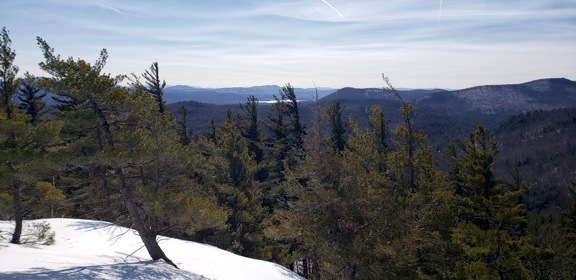
Summit views out toward Schroon Lake and Pharaohs (Provided photo — Spencer Morrissey)
A large part of what I like to do is explore some “untapped” territory, and the trail-less peaks of the Hoffman Notch Wilderness is one area I like to stomp around. Two Creeks Peak, as the title indicates, is not an officially named peak, but one that I gave it because of the “two creeks” that drain its slopes.
A secluded trailhead located off state Route 9 in Schroon Lake, was home to the start and finish of this little adventure. The trailhead is named for Dirgylot Hill, an interesting name for an interesting back-story. At least that’s what I imagine, since I have no idea where the name came from.
The Dirgylot Hill Trail is not a destination hiking location but more of an access to the Hoffman Notch Wilderness by way of a vehicle culvert under I-87. The trail does not even go up Dirgylot Hill or any other peaks on that side of the Northway. It does, however, get users to some old carriage roads through the wilderness, which is a nice addition to those who like to explore.
We started from the unplowed parking area by nudging our vehicles off the white line, strapping on our snowshoes, turning on the GPS and shouldering our winter packs. The trail was not freshly touched, but it did appear to have been walked upon at some point within the last month.
I crave the faraway; that is one reason I tend to explore the unique features of the Adirondack Park. I also crave discovery, and that is what this day was about.
We made quick time to the vehicle culvert and clunked around on our snowshoes across the bare sand and paved drive. The sound was deafening, like Clydesdale horses trapped in a tin can.
The snow was deep, with a thin layer of crust that seemed to hold one just long enough to give hope, only to yank it away just when we were most vulnerable. About a half-mile or so from the positive side of the culvert, there was an obvious fork in the old carriage road. Mind you, none of this was marked.
Left, which I have been on before, slowly goes around the back side of Dirgylot Hill and ends near the base of Jones Hill.
Right, I had been this way before too, leads faintly at best to the base of Blue Ridge Mountain. We would head to the right, which is technically north for those of you following along with a map.
This secondary carriage road is quite obvious, and in the summer when tread can be seen, it is even more so. The route is actually a very scenic walk dotted with tall trees, massive boulders and a babbling brook, a destination in itself.
Having seen the trail many times and its tough winter-like conditions getting us no farther any quicker, we opted for a direct route and started the planned bushwhack. The tall trees drew my eyes fondly as we passed beneath old growth pines, beech, cedars and aspen. Rocky terrain added a bit of excitement.
The climb over the small first peak was steep and deep, but we made it in marathon time, so it seemed. The mostly wooded summit didn’t offer much, but the seclusion was calming.
We steeply descended this to the north where we encountered one of the two creeks for which it is named. The crossing seemed to appear to be an issue, but the local deer population was nice enough to find us a plausible route across without the fear of wet feet.
The climb up the sub-summit south of the peak was also a steep endeavor, one for which we battled and skirted cliffs draped in ice. The snow was so cold it had no traction.
This boulder-topped summit was laying the groundwork for what might prove to be a great day in the mountains. Even with no view, we felt at home as the peaceful retreat freed us of man’s everyday woes. A short, steep descent allowed us a butt-slide or two. One may have been more of a glorious fall, for which I was awarded an “8.” I think it was better than that, but once the winter Olympics have a game for such a skill, I can again readdress my technique for graceful toppling.
The final climb was made of more cliffs and one butt-clenching, snowshoe maneuvering, game of chance. The highest point of the mountain was guarded by extensive rock formations and a long rock barricade. Many of these, we managed to walk around with a bit of patience, but one, one that looked to be a “doable” climb, was not so much so when we were face-to-face with it.
It wasn’t all that tall, and in the summer, minus the snow of course, it would have been a standard scramble. On this occasion, we had to use just the teeth of the snowshoe crampons on a lip no bigger than a duck’s bill and step up gingerly all while we placed the other in a snow pack that we prayed would hold. Well, it held, but I guess you figured that out.
The summit was not far from there and an easy stroll along an open ridge and one killer view of Hoffman and Blue Ridge mountains. We hung out in the sun for almost an hour before dropping off the top into a shallow gully, overrun by deer.
If I have learned nothing else over the years, it is that deer know how to safely get off a peak and around ledges. We used their route. We didn’t hit one iota of rock challenges. In fact it was a piece of cake all the way around the summits we hit earlier and back to the old carriage road. So uneventful in fact that I will spare you the step by step process of the step by step snowshoe route, and just leave it at that.
In closing, the day ended up with about 5 miles of snowshoeing, one surprisingly nice peak, one broken snowshoe (which happened on the way out, but it wasn’t that bad and surely not interesting), 3,500 calories burned and a pint of lager at Paradox Brewery.
Columns
ON THE SCENE: Before there were trees
MARTHA SEZ: ‘This is what happens to the elderly brain, mine included’
Biff says he knew the war our country is now conducting with Iran didn’t surprise him one bit. It was in the ...

ON THE SCENE: Olympians on the Olympics
MARTHA SEZ: ‘Then there is the sad but true … story of the cow in the cemetery’
Every once in a while, I look back at columns I’ve written over the years and reminisce. There was the time, ...
LIONS CLUB LOG: Lions Club meets LPHS senior Joselyn Hernandez
The Lake Placid Lions Club has had a busy start to the 2025-26 seasons involving the Annual Radio Auction, ...