Find the right marsh to suit your needs
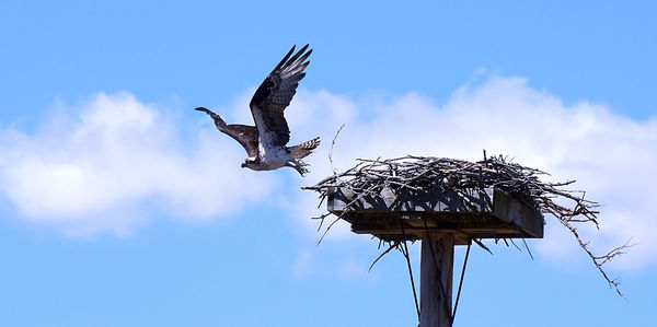
An osprey leaves its nest at the Wickham Marsh Wildlife Management Area in Peru on Monday, May 14. The nest is located at a marked wildlife viewing location on one of the marsh’s trails. News photo — Justin A. Levine
CHESTERFIELD – The extended winter may have actually shortened mud season in the Adirondacks this year, but if wet trails are your mind there is a trio of wetland hikes in and around the Blue Line that offer a little something for everyone – from the wheelchair bound to hikers to paddlers to nature lovers and bird watchers.
—
Wickham Marsh Wildlife Management Area
Wickham Marsh Wildlife Management Area is located in the town of Chesterfield, just down the road from Ausable Chasm and near the shore of Lake Champlain. Although the 862-acre state Department of Environmental Conservation property is mainly managed for wildlife, there is an extensive network of trails that can accommodate pretty much anyone.
The upper loop, off of state Route 373, is an easy and flat hike that will provide glimpses of all sorts of small mammals – including squirrels, chipmunks and mice – along with birds and possibly deer or other larger animals. From the parking area, go left and sign in at the trail register, then continue 0.2 miles on the property line, marked with red DEC trail markers. At the 0.2-mile mark, turn right onto a blue marked trail.
At about the 0.85-mile mark, there is a view of Lake Champlain on the left. It’s not the greatest or most breathtaking view, but it does kind of look like the lake is a sea, almost as if you were catching a glimpse of the Atlantic Ocean from the tip of Long Island.
After a mile, you can turn right to head back to the parking area or you can descend to the left down to the actual marsh. Going back to the parking area at this juncture will give you a nice 1.88-mile loop.
But the upper loop – situated on higher ground above the marsh – is far from the only option. There are four entrances to Wickham Marsh, including two on Lake Street and one of Giddings Road. The Giddings Road entrance also provides access to a number of trails, including a lollipop loop. If you have two vehicles, there are also a number of through-hike options that could be taken advantage of. There is also an accessible wildlife viewing area off of Giddings Road, but it is a stand-alone feature.
From Lake Street, there is a trail entrance and a hand launch for canoes or kayaks. The street, and adjacent railroad bed, form the eastern boundary of the marsh, and keep it from spilling into Lake Champlain, just a few hundred feet away. There are expansive views of the open water marsh from the road, and if paddling is your thing, then take advantage of the car top launch at the northern end.
But if birding, hiking, skiing or trail running are your jams, then park at the southern Lake Street trailhead. From there, the old road follows the edge of the marsh, with its dead trees, lily pads and abundance of bird life. It’s the type of spot that can be visited at different times of the year to get a whole new experience.
Following the trail, it’s just over three-tenths of a mile to an osprey nest platform. The day I was there, an osprey was perched on the nest and took a particular interest in me as I snapped some photos. Within a minute or so of my appearance, the osprey took off from the nest and flew a lazy loop out over the marsh. But to my chagrin, it was soon heading my way, flying just 30 feet overhead.
After a second flyby, I thought it best to leave the bird with the massive talons alone and go back into the woods. In case of an attack, I didn’t want anyone within ear shot to think a small child was being harmed, because I definitely would have screamed like a little girl if that thing came after me.
—
Willie Marsh
Just south of the Blue Line, in Fulton County, is another marsh area that can accommodate people of all abilities. After significant damage to the wooden boardwalk, the DEC replaced the boardwalk and reopened it to the public last year.
The Willie Marsh trailhead offers accessible parking, a privy, picnic area and access to the 0.4-mile boardwalk, which stretches out over the marsh and open water. The Willie Marsh trail also has interpretive signs so you have some idea of what makes a marsh special, and more adventurous folks can continue past the end of the boardwalk for about another mile. There should be trail guides and a map at the trailhead.
For more information on Willie Marsh, go to www.dec.ny.gov/lands/106893.html.
—
Silver Lake Bog Trail
The Silver Lake Bog Preserve is owned and operated by The Nature Conservancy, but it is open to the public, albeit with some restrictions. Dogs, hunting, camping and motorized vehicles are all prohibited, but that’s a small price to pay for a roughly one mile walk along a boardwalk and then on a trail to spectacular views.
The trail starts off on boardwalk as it moves through, “a black spruce-tamarack bog, northern white cedar swamp, a hemlock northern hardwood forest, and a pine ridge,” according to TNC. From the end of the half-mile boardwalk, visitors can continue on another half-mile on the Bluffs Trail, which moves through a hardwood forest and onto a pine ridge.
The Bluffs Trail gains about 200 feet in elevation before opening up for views of Silver Lake and Whiteface Mountain in the distance.
To learn more about the Silver Lake Bog Preserve, visit www.nature.org.
Outdoors

DEC: Spring turkey hunting season opens May 1 in Upstate New York

Adirondack Mountain Reserve parking system starts May 1

Ski. Season. Over. (mic drop)

Lake Placid’s Cobble Hill trail closed weekdays until May 3

Northville-Placid Trail celebrates centennial
