VISITING LAKE PLACID : A different world: A winter climb up Mount Colden
KEENE — My heart pounded, not from the 2,500 or so feet we had ascended over the last couple of hours, but for the unnerving uncertainty that lay before me.
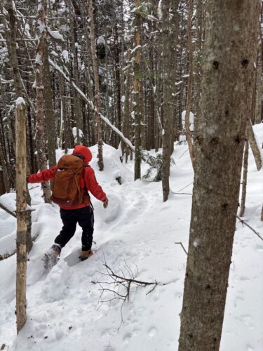
Atop Mount Colden’s false peak, an exposed 4,500-foot knob 0.4 miles and a couple of hundred feet beneath the true summit, on Tuesday, Feb. 24, the trail had all but disappeared. Like sand leaving a sieve, gusty winds made quick work, pushing the fine snow into the trench, covering the tracks that we had been easily following through the protected woodlands below.
Normally, plodding my way through the snow wouldn’t give me pause. But it’s a different world up there, especially in winter. Margins are small, and the consequences of error are magnified. Every step mattered.
All I could do was guess where the packed trail lay ahead of me, spear the snow with my trekking pole to test its sturdiness and inch forward one step at a time. The summit looked an eternity away at the few glances I took. Otherwise, I was solely and completely focused on making sure I got the next step right.
Not only was the snowpack north of six feet — as evidenced by shoving our trekking poles completely underneath the snow, and then being able to push them a couple of feet further — but the scraggly three to four foot pine trees notoriously clustered around many Adirondack summits made for a mindful of “spruce traps.”
Those form as the snow loosely falls around the pine bows, creating air pockets that become invisible once the tree is fully covered by snow. If you’re really taking your time, you might get lucky and feel one out surveying with a trekking pole. Otherwise, and even then, they’re usually undetectable. Unfortunately, the most common way of finding them is taking a step and having the snow give way underneath, and down you go.
If it’s a small tree or air pocket, stepping out is self-manageable and straightforward. The bigger the sink gets, obviously, the more difficult that becomes. Fortunately, I was joined on this hike by my college friend, Tommy. Hiking as a pair, I knew that if one of us met a particularly dastardly spruce trap, we’d at least have the other person to help with the bailout.
But that could still have been a 10-minute delay. With an air temperature around zero and a wind chill far below that, it was a situation to avoid at all costs. So along we went, one step at a time, made only after thorough testing with the trekking poles.
It was only a few hundred feet until the trail dipped back into the trees, and the defined tracks returned. I can’t recall how long it actually took us to get through that section.
We couldn’t have been moving much faster than half a mile per hour, yet the adrenaline coursing through me made that stretch feel like it went by in a flash.
After a small descent to the col, or saddle, between the false and true summit, the uphill resumed. Fortunately, approaching from the east, that side of Colden had been relatively sheltered from the winds that day, and the tracks before us remained visible, all the way up to the 4,714-foot summit.
After a few quick photos, we high-tailed it out of there. While the partial views between clouds of Marcy, Algonquin, the 20 or so other Adirondack High Peaks, Lake Placid and the surrounding landscape were magnificent, the wind chill demanded a quick retreat, knowing that we had a short window to get back up and over the false summit before the wind did its work on our tracks.
Once past that, and back in the trees, a sense of relief washed over me. Sure, we still had 7 miles to get back to the car, but it was all downhill from here — in the best way possible. The descent was aided by excellent winter trail conditions. The smooth snowshoe-packed trail transformed what is in a muddy, boulder-filled creekbed of a trail between Lake Arnold and the Avalanche Pass turnoff in the summer to a smooth glide-path in the summer.
<The trail
The most common and direct route to Mount Colden begins at the Adirondak Loj trailhead near Heart Lake. From there, it’s 2.3 miles of generally easy-going to the Marcy Dam. We, however, started our hike from the South Meadows parking lot, which is about a mile before Heart Lake and on the left when driving in from state Route 73.
While about 1.4 miles longer, in each direction to Marcy Dam, than starting from Adirondak Loj, it’s also easy-going terrain through — as the name would suggest — meadows and small rolling hills, with peeks of Wright Peak’s slides seen through the leafless trees. A column dedicated to just the South Meadows lot to Marcy Dam, albeit in spring conditions, can be found at tinyurl.com/3w4r4trv.
At 3.7 miles, we arrived at Marcy Dam, in good spirits and pleasantly surprised by the lack of wind, compared to what had been forecasted the night before. We had tentatively changed our plans to hike Table Top and Phelps mountains instead of Colden. They have less alpine exposure to the wind, but with a completely calm breeze at Marcy Dam, we shifted back to “Plan A,” noted that in the sign-in register and pressed on.
The next 1.1 miles to the Avalanche Pass junction is a gentle uphill, passing numerous campsites — all of which appeared understandably empty in the dead of winter — and following Marcy Brook.
While officially closed by the state Department of Environmental Conservation due to a large debris pile from a summer mudslide, the Avalanche Pass trail appeared well-traveled, with numerous ski tracks leading past the “closed sign.” The blue tape that was roped across the trail in the summer had fallen to the ground and was in a neat bunch beneath one tree, though the “closed” sign was still nailed to the tree. I can’t speak for what lies beyond it, as we continued up toward Lake Arnold.
This is where the steady climbing begins. The trail gains about 1,200 feet over 1.5 miles. While it’s nothing especially steep nor technical compared to most of the other High Peaks, the ascent is nothing to scoff at. We found ourselves taking frequent breath-catching breaks.
The trail was well-packed to Lake Arnold, never a given for a High Peak trail. We crossed our fingers that this would continue up Colden, and were relieved to see a set of three ski tracks continuing that way. The trail levels for a bit at Lake Arnold (6.4 miles from the South Meadows lot) before the steady climbing resumes.
This is where the aforementioned “other-worldly” snow depths began to set in. As much snow as we have in Lake Placid and the Tri-Lakes region, I was gobsmacked seeing just how much snow was in the mountains. It was both beautiful and humbling, knowing that the snowpack under my feet exceeded my height. Thankfully, the trail was well-packed, and unlike some other hikes, there was no sinking in and sliding back down with every step.
From Lake Arnold, it’s another 0.9 miles to Colden’s false peak, and from there, another 0.4 miles to the true summit — the trickiest part of the hike. All said, we clocked 15.5 miles for the day, finishing in 8 hours and 15 seconds. Had I been paying attention to my watch, I would have sprinted to the finish line in an effort to shave 16 seconds. C’est la vie.
Reflecting on this hike, my biggest takeaway is that two things can be true at the same time. By High Peaks standards, this was a fairly easy hike — in its distance, elevation gain and trail conditions. At the same time, by any reasonable standard, this was a grueling hike and highlighted how quickly trail and weather conditions can change in winter, especially above treeline.
Losing the trail for a few hundred feet was scary, and I couldn’t imagine being in that situation by myself — especially if the weather conditions had been any less tame. The same goes for any of the High Peaks above treeline, including but not limited to Marcy, Algonquin, Haystack, Skylight, Whiteface, Dix, Basin, Iroquois, Saddleback, Gothics, Wright, Giant, Santanoni and Panther. It’s a fine balance between breathtaking beauty and unforgiving conditions.
With nice weather and good preparation, Colden’s location, sandwiched between the two tallest peaks in the state, Marcy and Algonquin, makes for a fun, high-adventure hike with stunning 360-degree views. For more information on winter hiking safety from the DEC, visit tinyurl.com/unw4nz43.
Local News
Forest ranger recalls saving hiker lost for two days in Dix Range
Snowshoer found dead in lean-to in Pharaoh Lakes Wilderness
SCHROON — A Florida man was found dead in a lean-to in the 44,400-acre Pharaoh Lakes Wilderness in southern Essex ...

Ad’k Life announces photography contest winners
Some see Olympic blueprint for a 3rd Lake Placid games
CORTINA D’AMPEZZO, Italy — Imagine: A sprawling world-class city and a small mountain village with a rich ...

Cheers across US after men win first Olympic hockey gold since 1980