VISITING LAKE PLACID: A tale of two trails
Connery Pond to Whiteface Landing and Whiteface Landing to Eagle Eyrie
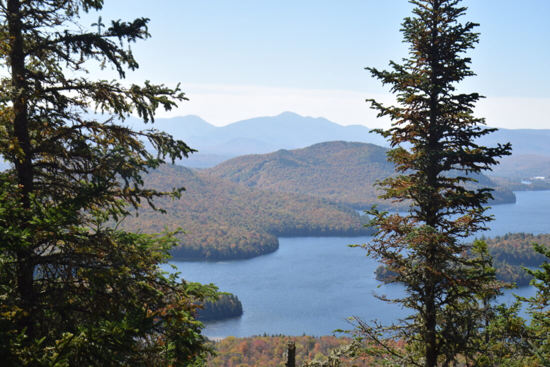
Lake Placid’s East Lake is seen from Eagle Eyrie, with Mount Whitney seen in the foreground in Lake Placid on Monday, Sept. 29. The mountains in the background, from left, are Mount Colden, Wright, Algonquin, Boundary and Iroquois peaks, and Mount Marshall. (News photo — Chris Gaige)
LAKE PLACID — It’s easy enough to set sights on the Olympic Region’s tallest peaks, but some of the region’s most rewarding adventures lie in its quieter corners, especially when the area’s most popular trails are teeming with leaf peepers.
The trail from Connery Pond to Whiteface Landing offers an easy-going and gentle stroll through the woods to a picturesque destination. For those looking for something more demanding and off the beaten path, the elusive, rugged and rarely traveled add-on adventure from Whiteface Landing to Eagle Eyrie demands sharp navigation skills and total focus.
–
Getting there
–
Traveling east from Lake Placid, the seasonal driveway is on the left side of state Route 86, about 3.5 miles from downtown Lake Placid. The driveway comes up quickly. It’s marked by a state Department of Environmental Conservation sign with trail distances, though the sign is small and a bit weathered.
From the intersection, it’s a 0.6-mile drive down the dirt road to the trailhead. The driveway is narrow and bumpy. It’s a single lane driveway for two-way traffic, and drivers should be courteous to oncoming traffic, keeping in mind what the nearest pull-over spot could be. The winter parking area and gate are close to state Route 86. Those looking to complete the hike in the winter should note the extra 1.2 miles — 0.6 miles in, and 0.6 miles out — and plan accordingly.
–
Connery Pond to Whiteface Landing
–
From the summer trailhead, the route begins climbing a small shoulder around Connery Pond, cresting at around 0.2 miles before descending to the pond’s northwest shore at around 0.4 miles. This part of the route is on private lands, with an easement for public trail use. Hikers should take care not to venture off the trail, and stay off private driveways that intersect it.
The trail continues level past Connery Pond, crossing onto to state forest preserve around 0.6 miles. Here, it begins a gentle to, on occasion, moderate climb through mixed woodlands. The trail is wide, well-defined and mostly smooth, with a few rocky patches on some of the ascents.
After a brief level stretch, the trail begins a gradual descent — dropping about 60 feet over the next 1.1 miles. At 2.6 miles, it reaches a four-way intersection. The trail right goes to Whiteface Mountain, the unmarked path straight ahead leads to Eagle Eyrie (more on that below) and a short 0.1-mile trail to the left leads to Lake Placid’s shoreline and a boat dock.
There are several good picnic spots here, and a boat dock that provides good views of Hawk and Moose islands, as well as McKenzie Mountain, Mount Tamarac and Mount Colburn.
The relatively short mileage (5.2 miles, accounting for the return to the trailhead from here) makes it a perfect half-day activity for those looking for a walk through the woods without a strenuous mountain climb.
–
Whiteface Landing to Eagle Eyrie
–
As straightforward and gentle as the trail to Whiteface Landing is, the trail from there to Eagle Eyrie is anything but. It’s not a state-marked trail, is sparsely maintained, seldom trafficked and is extremely difficult to navigate.
Those attempting Eagle Eyrie from Whiteface Landing should have ample wilderness navigation experience, have the requisite tools and know how to use them. It’s more likely than not that hikers will get off trail (a.k.a. get lost) several times along the way, and know what to do when that happens. Cellphones are not a reliable for this, and cellular service is largely nonexistent between Whiteface Landing and Eagle Eyrie.
With these caveats in mind, the hike to Eagle Eyrie proceeds from the four-way intersection near Whiteface Landing. It follows the remnants of an old woods road for a time for a bit, but at 0.2 miles (2.8 miles from the Connery Pond trailhead), the trail goes right into the woods, marked sporadically with blank white discs.
The trail rejoins the old road around 0.3 miles (2.9 miles from the Connery Pond trailhead), continuing through a muddy and marshy stretch before crossing Whiteface Brook at 0.8 miles (3.4 miles from the Connery Pond Trailhead). The trail is extremely difficult to find here, as there are several splinter paths that go to various crossing points.
After the brook, the trail oscillates between following the relative clearing from the old road, and heading through the woods. When it’s not following the clearing, the trail is generally uphill of it — to the right when hiking toward Eagle Eyrie and to the left on the way back to Connery Pond.
At 1.4 miles (4.0 miles from the Connery Pond trailhead), the trail comes to the three-way intersection with the Lake Placid Shoreowners Association Trail just before another small brook that runs into Lake Placid’s Echo Bay. Unmarked, the trail to Eagle Eyrie turns right here and immediately proceeds uphill, while continuing straight past the brook eventually winds around Lake Placid’s west shore and comes out at Blodget Way.
From the intersection, it’s a moderate but steady climb as the trail gains about 700 feet over the next 0.8 miles. There are a few short scrambles, but nothing too technical. The biggest difficulty is, yet again, staying on the trail, which is sporadically marked by white and blue Lake Placid Shoreowners Association discs. There are several spots along the ascent where it’s overgrown, and there are several fallen trees requiring short workarounds.
The trail becomes steeper closer to the top. About 0.1 miles from the end, the trail passes by a 20 to 30-foot rockface. The route itself doesn’t climb the rockface, though it serves as a good landmark letting hikers know they’re almost at the trail’s end.
The trail doesn’t go to Eagle Eyrie’s true summit; rather, it continues at a generally level pitch from the rockface and comes to a lookout with a wood-carved eagle sign marking the end of the route, 2.2 miles from Whiteface Landing (4.8 miles from the Connery Pond trailhead, and a total of 9.6 miles when accounting for the return to the Connery Pond trailhead).
The lookout’s view is partially obscured by trees, but peering beyond the branches provides a worthwhile view over Lake Placid’s East Lake, in my opinion. It’s certainly not the most expensive view in the Adirondacks, but it sure is unique.
In the background, a portion of Mirror Lake can be seen, along with some buildings in downtown Lake Placid, including the Olympic Center. Behind those, the High Peaks rise up. Marcy, Gray, Colden, Algonquin, Wright, Iroquois, Marshall Street, Nye, Santanoni, Panther and Couchsachraga can all be seen from Eagle Eyrie, albeit some require bending down or jumping up to catch a glimpse through the branches.
While the view was neat, for me, Eagle Eyrie was more about the journey than the destination. This probably sounds like a perplexing paradox, given the trail’s description and, indeed, I became lost several times. However, there was something infatuating about being completely and solely committed to the task in front of me.
My mind often wanders while hiking. Not this time. I simply couldn’t afford not to be. Following the trail, or getting back on it for that matter, always demanded paying full attention to my surroundings. Whether it was eyeing the next white disc, noticing a subtle but sharp turn, or feeling when I stepped off the relatively firm trail tread into a softer bed of forest floor — indicating I needed to turn back and find the tread — I needed to gather all of the clues possible to stay en route.
I also think much of the enjoyment I derived from this challenge is owed to the expectations I had going into it. I researched and knew it was going to be a tough route. I expected to get lost, so when I did, there was no panic, just a methodical shift to a mini game plan to get back to the trail — pausing, looking around and carefully retracing my steps, fortunately got the job done. Just in case my map, compass and satellite inReach were in my backpack, and ready to be deployed if needed.
Of all the adventures I’ve completed for this column, I’ve never been more focused in the moment than I was for Eagle Eyrie. Put simply, hiking Eagle Eyrie demands eagle eyes — a challenge I relished.
Local News
Whiteface Memorial Highway sees busiest season in 49 years
WILMINGTON — It was a banner year for the Whiteface Veterans’ Memorial Highway, which closed for the season on ...
Lake Placid Turns Out to Honor Veterans
LP Holiday Village Stroll Dec. 12-14
LAKE PLACID — Community event organizers are encouraging Adirondack residents and visitors to support the ...
Herb Brooks statue to be unveiled in Lake Placid in January
LAKE PLACID — As the Olympic world prepares for the 2026 Winter Games in Milan/Cortina, Lake Placid will harken ...
LPCSD to considers field improvements at upcoming public hearing
LAKE PLACID — The Lake Placid Central School District is slated to hold a public hearing at its district office ...