VISITING LAKE PLACID: Huffing it up Haystack
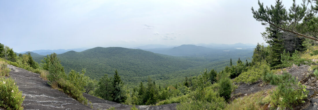
Haystack Mountain's summit views are seen on Tuesday, Aug. 5, looking to the south with Big Burn Mountain seen at center, along with Scarface Mountain behind and to its right. Smoke from wildfires in Canada obscured views of some of the High Peaks, which can be seen from here on clearer days. (News photo — Chris Gaige)
LAKE PLACID — Sure, Haystack Mountain in the McKenzie Mountain Wilderness may not be quite as difficult as the similarly named Mount Haystack in the High Peaks Wilderness — the third-tallest peak in the state at 4,960 feet. Even though Haystack Mountain’s summit is some 2,000 feet lower, climbing this mountain is no joke.
Of course, I did myself no favors going into the hike as I started from the lower, and more difficult, of two trailheads during the middle of a warm and hazy summer day on Tuesday, Aug. 5. There are two commonly used trailheads for Haystack Mountain, one beginning at the Jackrabbit Trail parking lot on Whiteface Inn Lane and the other from state Route 86 approximately 2 miles west of the village line.
The Jackrabbit Trail is considered the easier of the two approaches. It begins about 275 feet higher in elevation than the state Route 86 trailhead, has fewer “ups and downs” en route to the summit and is a couple of miles less distance overall.
Since I had previously hiked the Jackrabbit approach, I decided to give the state Route 86 approach a go. The trail starts off deceptively easy. It winds through tall pine forests and while there are some roots and rocks could twist an ankle if one isn’t paying close attention to their feet, the trail is easy to follow for the most part.
It’s clearly marked with blue discs and there are no obstructions that require bushwacks around.
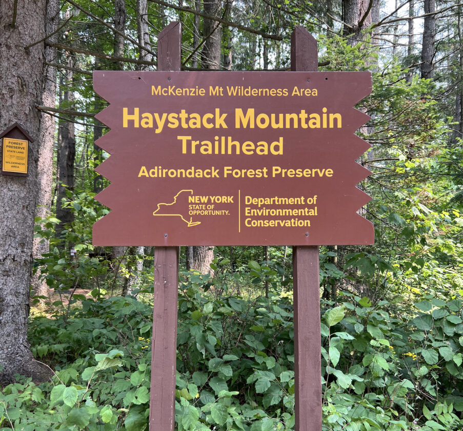
A sign for the Haystack Mountain trailhead along state Route 86 in the town of North Elba, approximately 2 miles west of the village of Lake Placid, is seen on Tuesday, Aug. 5. (News photo — Chris Gaige)
There was also next to no mud on the path, although the Olympic region hasn’t received much rainfall the past couple of weeks. The trail climbs gently at first, gaining about 250 feet over the course of a mile. A similarly gentle descent follows for the next 0.7 miles, as the trail gives up its initial gains to level out along a small stream at an elevation that’s slightly beneath that of the trailhead.
The stream, while picturesque, had the unfortunate disposition of being a deerfly magnet, and I was swarmed for a bit. I picked up the pace in a futile attempt to shake the flies, which only seemed to attract more. With constant swatting and waving my hands around, though I surely looked like a buffoon, I was able to avoid any bites.
The trail begins gently climbing as it more or less parallels the stream, eventually coming to a junction. It’s well-marked and a sign indicates the trail to Haystack goes left, while the route that meets up with the Jackrabbit Trail — with access to McKenzie Mountain, as well as the other backside way up Haystack — goes right.
Bearing left at the junction, the trail soon comes to an old dam. Though the water levels were lower than usual, the dam was easy to cross as there was no water flowing over it — something that could perhaps be trickier during periods of excessive rainfall.
After the dam, which is about 2.1 miles from the trailhead, the serious climbing begins. Though there are no technical areas that require scrambling, the pitch feels unrelenting. There were several times on the ascent where sunlight would peek through the trees — leading me to think I was almost at the summit — just to have my hopes dashed as it was just a small break before the trail would turn and continue making its way up Haystack’s slopes, seeming to grow ever steeper the further I went.
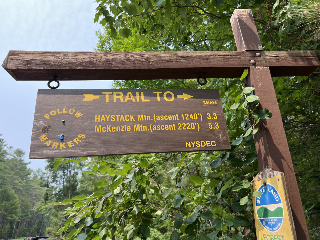
A distances and ascents sign for Haystack and McKenzie mountains is seen at the Haystack Mountain trailhead along state Route 86 in the town of North Elba, approximately 2 miles west of the village of Lake Placid, on Tuesday, Aug. 5. (News photo — Chris Gaige)
At long last, Haystack’s wide 180-degree open summit came into view. With sweat beading down my face, I took the last few steps to the outlook and admired the views. Though much was obscured by wildfire smoke, which caused an opaque haze, good views of the more immediate surroundings, including Big Burn Mountain, the Sentinel Range, the Sawtooth Mountains and Oseetah Lake were seen.
After collecting myself, I began the trip down, treading carefully on the steeper sections.
I thought about jumping into the pond by the dam to cool off, but without a towel in my backpack, I didn’t want to walk the last 2 miles sopping wet. I zoomed past the “deerfly corridor,” jogging in the more open spots of the trail and easing off on the pace when the gentle uphill — what was the first stretch of downhill on the hike in — began.
I was back to the trailhead in about 2.5 hours, helped by some more spurts of jogging on the way out. The total mileage was 6.7 miles, with an elevation gain — including Haystack’s “actual” ascent, and that first rise that was subsequently lost then regained — was 1,886 feet.
In concurrence with most of the information online, I found the Whiteface Inn Lane trailhead approach to be considerably easier. While starting from state Route 86 has its perks — the parking is easier and the small pool by the dam did look inviting — it’s more of a challenge and those less sure of their hiking abilities or those hiking Haystack for the first time might be better off starting from the Jackrabbit Trail lot.
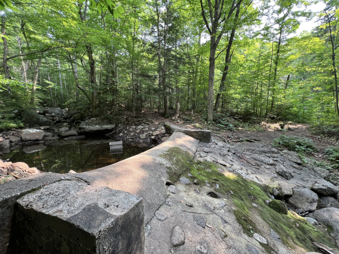
An old dam is seen along the trail just past the junction with the trail to McKenzie Mountain is seen on Tuesday, Aug. 5. (News photo — Chris Gaige)
Still though, starting from state Route 86 provides a nice and well-maintained trail overall and makes for a good half-day or so hike for those in good physical shape looking for a serious climb without the all-day rigor of a High Peak. No matter the approach, Haystack Mountain is part of the Saranac Lake 6er hiking challenge. For more information on that, visit tinyurl.com/zyarm65j.
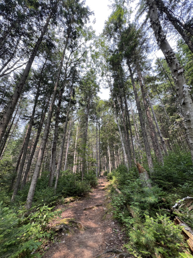
A pine forest is seen during the first mile of trail to Haystack Mountain beginning from the state Route 86 trailhead on Tuesday, Aug. 5. (News photo — Chris Gaige)
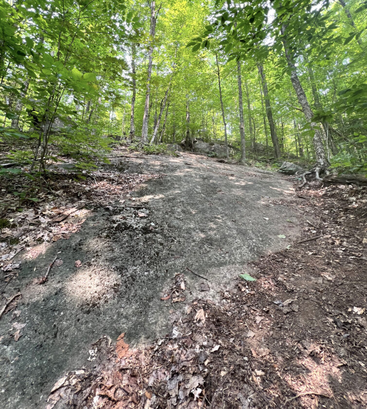
A rock slab along a steeper section of trail approaching the summit of Haystack Mountain is seen on Tuesday, Aug. 5. (News photo — Chris Gaige)
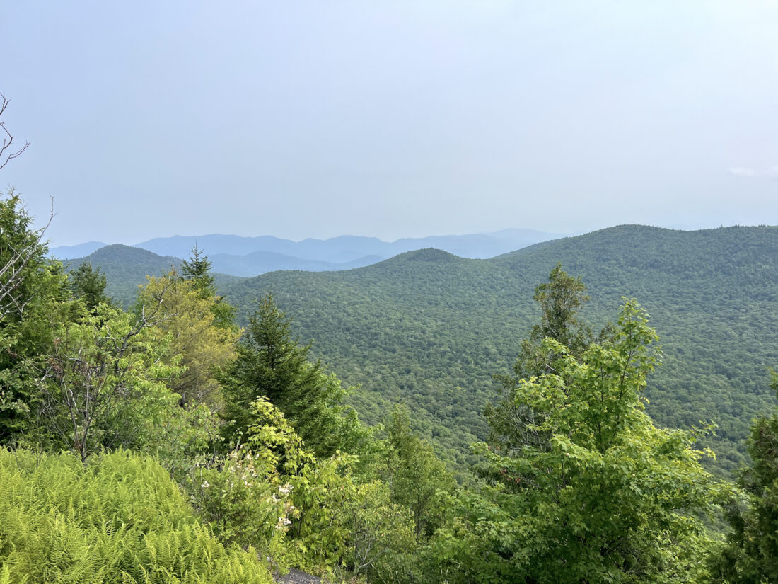
Haystack Mountain's summit views are seen on Tuesday, Aug. 5, looking to the east with the Sentinel Range seen in the background. Though not visible in this photo, Lake Placid is between the near and far ridgelines. (News photo — Chris Gaige)
Local News

Kirkby is excited to make Olympic history
Festivities planned at Saranac Lake Winter Carnival Ice Palace
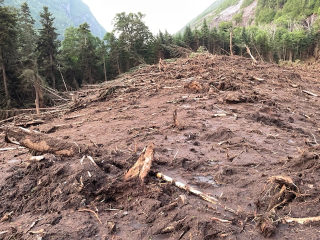
DEC plans Avalanche Pass work this summer

Lewis residents sound off at howitzer information session

2026 Milano Cortina Winter Olympics now underway