VISITING LAKE PLACID: Hiking the mega loop
High Peaks of Gray, Skylight, Marcy, Table Top

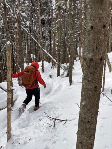
Chris Gaige “balances” in the wind on final approach to Mount Skylight on Friday, June 20. (Staff photo)
LAKE PLACID — I had set an alarm clock, but that’s not what woke me up on Friday, June 20. Sheets of rain pounded down on the roof and the wind swirled about outside, howling at times. It was just before 6 a.m. and far from the scene I had hoped to see out my window.
When I went to bed the night before, the forecast called for some scattered overnight showers with precipitation tapering by dawn. Not this! Throughout the week, I had been planning an all-day hiking excursion with my cousin Austin Davis, who lives near Plattsburgh.
I took another look outside and then immediately gave Austin a ring. He was scheduled to pick me up around 7 a.m. and I figured there might have been a chance he wasn’t on the road yet, allowing me a more convenient excuse to bail out. Wrong again! When he picked up the phone, I heard the unmistakable background noise of wheels in motion. He informed me that he was just about halfway to pick me up. I hemmed and hawed, contemplating on whether or not to call the operation off.
I took one last look at the radar. As promised (sort of), things were clearing up to our west and moving in, the question was just how long would it take.
“OK, we’ll probably be fine,” I said over the phone as I grimaced in my bedroom. “See you in 20 minutes.”

Cousins Chris Gaige, front, and Austin Davis smile at Mount Skylight’s summit, with Mount Marcy seen in the background on Friday, June 20. (News photo — Chris Gaige)
Fortunately, our intended route gave the weather a few hours to improve before we’d be up high, above treeline — when Mother Nature’s cooperation becomes paramount. We planned to start at the Adirondak Loj and hike Mount Skylight and Gray Peak, two of the Adirondack 46 High Peaks that require a great distance of walking in from the trailhead before getting to the mountain climb itself. In this case, that would be just under 8 miles one-way.
We pulled into the Loj parking area, the rain was still coming down as a drizzle, and things were pretty quiet. The parking attendant asked what our intended destination was. I paused, gave a self-deprecating half-chuckle, and said Gray and Skylight.
“You know we’ve been receiving reports of 40 to 50 MPH winds up there this morning,” the attendant said.
The knots in my stomach tightened a bit, I thanked the attendant for the information and we continued to the parking spot. Fortunately, Austin is one of the most outgoing and upbeat people you’ll meet and we threw our faith in the radar’s latest scan showing improvements ahead “Well, we can always turn back if things get too bad,” he said.
It sounded good enough to me. At 7:25 a.m., we struck off on the Van Hoevenberg trail with blazing pace, covering the 2.3 miles to Marcy Dam in just over 45 minutes. The drizzle had come to an end, and while Wright Peak and Mount Colden — both partially visible from the dam — were still cloaked in clouds, we took it as a good sign.
Faithful readers may recall my praise for this stretch of trail in last week’s column. It’s flat, wide, and devoid of boulders and other “fun” obstacles that seem to manifest themselves on just about every other segment of trail in the High Peaks Wilderness.
The rain last night made everything muddy to the bone. My shoes were already mud covered and my lower legs were caked in it. In a weird way, getting immersed in the mud early made it psychologically easier. We were laboring under no false pretenses, and knew that’s what the rest of the day would have in store. Onward!
We continued past Marcy Dam toward Avalanche Pass, peeling off to the left about a mile later for the trail to Lake Arnold. This is where the climbing started. We gained about 1,200 feet over about 1.5 miles en route to Lake Arnold. Unfortunately, continuing on to Gray and Skylight meant we had to relinquish about 500 feet of that as we descended toward the Feldspar Brook lean-to, where the trail to Gray and Skylight picks up.
This is a notoriously — even for the rugged Adirondack standards — diabolically muddy stretch of trail. A portion of it goes through a bog. While some portions of trail had wooden planks installed by intrepid trail improvement crews over the years, you were on your own for other parts of the bog.
Austin and I did the best we could around the bog, each of us sustaining multiple falls into the muck, one going as deep as my knee trying to rock hop a portion of the bog. C’est la vie. At other points, the trail was a stream. The only upside was I had ample opportunities to drench my mud-covered legs in running, relatively clear water to give myself a trail bath.
We made it to the lean-tos around 10 a.m. and took a left at the junction to make the second serious climb of the day. Despite getting drenched in the mud, our energy levels were high and we pressed forward in ernest, climbing another 1,000 feet over 1.2 miles. We pressed forward at a steady pace, and made it to the turnoff to Gray Peak in about 35 minutes from Feldspar.
At 4,840 feet, Gray Peak has the honor — if you want to call it that — of being the tallest of the “unmarked” 46 High Peaks, those without official trails to their summits. Unfortunately, heavy trail usage that’s come with hiking’s rise in popularity has left these unmarked trails severely degraded, with erosion and widening rampant. While I scoff at, in any way, turning this into a glass-half-full moment, I will note that the trail was not difficult for us to follow from a navigational standpoint.
It was rugged, though. The trail was rocky, steep, at times a running stream and narrow. Forward progress slowed, and despite only being a half mile from the junction, the trail seemed to take forever. Fortunately, alleviating our fears at the start, the wind had calmed down considerably at Gray’s summit. It was still blowing, but the gusts had diminished to between 20 and 30 mph– nothing that would knock us over. The clouds continued to lift, and the surrounding High Peak summits, most prominently Mount Marcy and Mount Skylight, became visible.
We slowly made our way back down Gray, careful not to injure ourselves on the steeps, and headed for Mount Skylight, whose junction is only about 0.3 miles beyond that of Gray Peak. The trail to Skylight is marked and in considerably better condition than Gray’s trail. At 4,926, Mount Skylight is the fourth tallest mountain in the state, and its bald summit offers spectacular 360-degree views. The clouds and wind continued to lessen, and we were greeted with stunning views of — for the purposes of abbreviating the list — the majority of High Peaks.
Riding a wave of euphoria on the summit, Austin and I made the decision to change our route. We had originally planned on an out-and-back, returning the way we came through the Feldspar lean-to and Lake Arnold. Although it would add on a bit more mileage and elevation gain, we decided to go up and over Mount Marcy from the southwest side and hook up with the Van Hoevenberg trail back to Marcy Dam and the Loj at Marcy’s summit.
We stopped for lunch on top of Mount Marcy after a breathtaking — both literally and figuratively — ascent and admired the views, looking down on Gray and Skylight where we had just come from. In contrast to my last hike up Mount Marcy, there was no Canadian wildfire smoke to deal with, and the views stretched well into the distance.
We continued down the Van Hoevenberg trail. The patch of snow had shrunken from the week before but was still hanging on (it’s likely gone by the time you’re reading this). As we made our way down, the first signs of fatigue were starting to take root. We decided to hike Table Top, another High Peak with an unmarked trail that begins from the Van Hoevenberg trail just below Indian Falls.
It was a High Peak that Austin had never done, and given the long daylight afforded to us this time of year, ample food and water reserves and “good vibes” at Indian Falls, we decided to add it to the day’s route — there were no warning lights flashing on our metaphorical dashboards.
Like Gray, the trail was in dastardly shape, driven by heavy usage. The trail started off level, climbed steadily, then leveled out again in the tenth or so of a mile near its summit, which offered partial views of Mount Marcy, Mount Haystack and numerous other surrounding High Peaks through the trees.
At this point, we were definitely feeing sore, but as they say, it was (almost) all downhill from there. We made our way back to the Van Hoevenberg trail, jaunted our way down to Marcy Dam and strolled back to the Loj.
In all, it was a 20.4 mile day, according to my GPS watch, which is slightly different than the mileage you’d find on a map, given all of the minor zigs and zags made throughout the day that start adding up eventually. It took us 11 hours and 13 minutes, and included a total vertical ascent of 6,919 feet.
It was an epic day, and while the trails were gritty and the distance grueling, the views were spectacular. Suffice to say, this route should only be taken on by those with frequent past hiking experience, are in strong physical shape and have diligently planned for a distance of this caliber, including making sure they have sufficient food and water packed, have a map and compass and a headlamp and batteries should nighttime hiking be required.
Also, those attempting hikes like this should always be ready and, more importantly, willing to turn around if conditions worsen. While we checked the weather closely and were reasonably confident in improving conditions, we were ready to turn around on or before Gray at any point if the winds were too strong or visibility became too low. For more hiking safety tips from the state Department of Environmental Conservation, visit tinyurl.com/7w6c5y9a.
While we hiked in a counterclockwise loop beginning with Gray, it could just as well be done in reverse, since the trail meets back up at Marcy Dam.
Those going for slightly less distance and elevation — and I mean slightly, because this is still a very long route — while not wanting to compromise on the views, consider shaving off Table Top and or Gray, as each of those peaks spur directly off of the route.
For avid hikers looking to challenge themselves in the High Peaks, these four peaks make for an intense, but fun-filled day.
Local News
VISITING LAKE PLACID : A different world: A winter climb up Mount Colden
KEENE — My heart pounded, not from the 2,500 or so feet we had ascended over the last couple of hours, but for ...
Forest ranger recalls saving hiker lost for two days in Dix Range
Snowshoer found dead in lean-to in Pharaoh Lakes Wilderness
SCHROON — A Florida man was found dead in a lean-to in the 44,400-acre Pharaoh Lakes Wilderness in southern Essex ...
Ad’k Life announces photography contest winners
Some see Olympic blueprint for a 3rd Lake Placid games
CORTINA D’AMPEZZO, Italy — Imagine: A sprawling world-class city and a small mountain village with a rich ...