VISITING LAKE PLACID: A shifty scramble to Balanced Rocks is richly rewarded

The Balanced Rocks are seen on Monday, April 21, with numerous High Peaks in the background. From left, Mount Marcy, Table Top Mountain, Gray Peak, Phelps Mountain, Mount Colden, Algonquin Peak, Wright Peak, Santanoni Peak, Panther Peak and Street Mountain are visible. (News photo — Chris Gaige)
LAKE PLACID — Nikon cameras are great. They take fantastic photos and are relatively user-friendly for a novice like me. Unfortunately, they have their limits in certain situations.
When scrambling up a 10-foot ledge on my way to the Balanced Rocks high above the Cascade Lakes, with any slip of a hand or foot resulting in all-but-certain doom, the Nikon D3300 becomes rather burdensome. Even though the camera only weighs about one pound, it felt like a cannon ball dangling around my neck — not to mention the added pressure of knowing that any contact with the jagged rocks would cause irreparable damage to the lens.
As I approached the ledge, I figured I could make my way up it safely while keeping my Nikon strapped around my neck in case a neat photo opportunity presented itself. Much like a clown at a circus, I was juggling too much. Fortunately, sound judgment came through and after taking the first step up the ledge, I realized I needed to back down — which I was still low enough on the route to do so fairly easily — and pack my Nikon back in its camera pack, which I had plenty of room for.
Looking back, it was a total no-brainer. The packing delayed my trip by about 30 seconds and quite possibly saved both device and yours truly from wreckage. On top of that, this wasn’t the only scramble. The route is filled with them, and even if I had made it through the first ledge unscathed, who’s to say what would have happened on the next one? Or the one after that? Or the one after …
As you might have gathered, the trail to the Balanced Rocks isn’t exactly a walk in the park. Sure, it’s easier — and much shorter — than most of the High Peaks, but the trail is rugged and hikers should be in good shape and be comfortable scaling rock scrambles. Those require calculated foot placements and using one’s hands for balance and strength to ascend some of the ledges.

The path to the Balanced Rocks, as seen on Monday, April 21, is itself rocky, rooty and at times difficult to navigate. (News photo — Chris Gaige)
It’s important to keep in mind when hiking that these tricky spots can be even more difficult to negotiate on the descent, when you’re traveling closer to gravity’s direction and it can act as a more readily accelerant should a slip or slide occur.
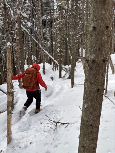
Like many trails in the Adirondacks, the trail to the Balanced Rocks is badly eroded in many spots, with roots once buried well underneath the soil now showing through in gnarly formations. Some spots have “side trails” that work around some of the tougher scrambles.
While I understand the desire to scout out a safer route, the fact remains that these splinter paths exacerbate erosion and trail widening, degrading the route over time and ultimately leading to a more dangerous situation in the future. To compound the problem, the trail is poorly marked in many spots, potentially leaving hikers uncertain as to what’s a side path and what’s the actual trail.
Fortunately, when I completed this hike on the morning of Monday, April 21, there was almost no ice. I say almost because there were a few small patches just before the scenic vista, but these were in a pine forest and had accrued a hefty crest of twigs and pine needles over the winter months that provided sufficient traction such that I did not have to deploy the microspikes that I had packed just in case.
It had fallen below freezing the night before and the temperatures had only reached the mid-30s as I hiked. That meant that most muddy patches of the trail were quite firm. I was able to walk right through the mud piles without sinking in and getting dirty. For what it’s worth, the trail overall was significantly less muddy than I predicted, aside from the firm mud. There had been no precipitation the day before, and much of the trail was dry dirt.

Markers at the junction about 1.35 miles from the trailhead are seen on Monday, April 21. On the ascent, a left turn takes hikers to Pitchoff Mountain's wooded summit while bearing right leads to Balanced Rocks. (News photo — Chris Gaige)
Had the trail been wet, the ledges and scrambles would have been markedly more difficult to manage. I raise all of these mitigating factors to show what a difference nice weather — or, conversely, how difficult bad weather — can make a hike in the Adirondacks.
While conditions in the mountains are subject to change on a dime and might end up different than what was forecast, checking a reliable source ahead of time, and double-checking for any changes (while one still has internet service!) shortly before beginning a hike can potentially prevent injuries, rescues and just an all-around less-than-ideal experience. Frankly, in my opinion, this hike would be horrible if there happened to be bad weather, low clouds and accordingly, no views from the Balanced Rocks!
–
The hike
–

Cascade Mountain, Upper Cascade Lake, lower right and Lower Cascade Lake, lower left, are seen from near the Balanced Rocks on Monday, April 21. (News photo — Chris Gaige)
The route to the Balanced Rocks (Balanced Rock, Balancing Rocks, Balancing Rock are all other nomenclatures I came across in my trip research that refer to the same area) follows the Pitchoff Mountain trail for most of its path. Importantly, there are two trails to Pitchoff Mountain that both have trailheads along Route 73 — one beginning west of its summit and the other to the east.
Though one could technically begin from the east, doing so would require climbing up and over Pitchoff’s summit and adding on about 8 extra miles. The far more direct route is from the west. The trailhead shares a parking area with the extremely popular trail to Cascade Mountain, about 8 miles along the highway from its terminus with state Route 86 in Lake Placid. Beware on busy days that the parking is extremely congested, and often fills up early in the day.
The Cascade trail heads south from state Route 73 and begins on the Keene-bound side of the highway. The trail to Pitchoff Mountain and the Balanced Rocks begins on the Lake Placid-bound side. Hikers should take extreme caution when crossing the highway and listen for vehicles, as there is a short-visibility bend in the road near the Pitchoff trailhead.
The trail begins with a wooden staircase up from the highway’s shoulder, with the sign-in register just a few hundredths of a mile into the forest. The trail begins climbing from the get-go, gaining about 230 feet in the first quarter mile, according to my GPS-tethered watch I use while hiking.
While it gets the heart pumping, there is nothing especially technical about this initial climb. The trail then flattens out and remains generally level — with a few small ups and downs — for the next few tenths of a mile. A view of the Balanced Rock’s outcropping can be first seen around 0.35 miles from the trailhead, although this will likely disappear as the deciduous leaves bud and the forest canopy builds in for the warmer months. From 0.25 to 0.85 miles, there’s only about a combined 150 feet of ascent, per my watch.

Ample exposed rocks around the Balanced Rocks, which make for a picturesque rest spot, are seen on Monday, April 21. (News photo — Chris Gaige)
The trail becomes more intense around 0.85 miles, with the first rock scramble. It’s a good first test, but hikers should note that the ensuing scrambles are a notch more difficult. Those begin around 1 mile from the trailhead, with the trail climbing steadily afterwards, with several areas of blowdown that have to be climbed over.
Around 1.35 miles, the trail reaches a junction. As one is ascending, the trail to the left continues to Pitchoff’s true summit, which is wooded and offers little in the way of views. The path to the right leads to the Balanced Rocks. There is a small disk marking these routes on a pine tree in the middle of the junction, although the text is small and weather-worn.
From the junction, it’s only about 0.2 miles to the Balanced Rocks, although the trail gets tricky to follow, as there are no markers, and several splinter paths. In general, stick to the right, although the splinter paths lead to scenic outlooks of their own.
–
The destination
–
The Balanced Rocks soon came into view, and the views were remarkable. The vista provides nearly 270-degree views of the surrounding landscape, with numerous High Peaks visible. To the east, Hurricane Mountain and its summit fire tower can be seen. There are also views of Mount Van Hoevenberg’s sliding track and the ski jumps.
These include Cascade, Big Slide, Marcy, Table Top, Phelps, Colden, Wright, Algonquin, Santanoni, Panther, Street, Nye, Emmons, Donaldson, Seward and Seymour. It was neat to see how the mountains take on a different visual profile when viewed from a different direction.
I’m accustomed to viewing these mountains from the north — whether from the village of Lake Placid, the Whiteface Mountain ski resort or the Adirondack Loj Road. From the Balanced Rocks, I could still identify various peaks, but some took a bit of extra time and corroboration based on the relative positions to other mountains.
The rocky outcropping is expansive, providing ample space for a break or even a picnic on a nice day. When gazing at the views, hikers should always be sure of their footing. There is a deep, perhaps 10 to 15 feet crevice near the actual Balanced Rocks. It’s easily avoidable, but if one isn’t looking and steps into it, injury or even death is quite possible.
After taking a few minutes to absorb the views, I began my hike back down. With my photos from the trip in hand, I packed my Nikon camera away once more, and began my descent, taking care and my time as I made it down the rock scrambles.
I was back at my car in just under two hours in total. My total distance came to 3.3 miles on my watch, with some of the distance attributed to mulling around on the rocks.
For hikers comfortable with some scrambles, the Balanced Rocks offer a relatively short climb to one of the most picturesque and unique views of the Olympic region.
Local News
VISITING LAKE PLACID : A different world: A winter climb up Mount Colden
KEENE — My heart pounded, not from the 2,500 or so feet we had ascended over the last couple of hours, but for ...
Forest ranger recalls saving hiker lost for two days in Dix Range
Snowshoer found dead in lean-to in Pharaoh Lakes Wilderness
SCHROON — A Florida man was found dead in a lean-to in the 44,400-acre Pharaoh Lakes Wilderness in southern Essex ...

Ad’k Life announces photography contest winners
Some see Olympic blueprint for a 3rd Lake Placid games
CORTINA D’AMPEZZO, Italy — Imagine: A sprawling world-class city and a small mountain village with a rich ...