REACHING THE TOP: Hikers of Mount Marcy rewarded through scenic sights
- News photo — Chris Gaige Lewis MacMillan, left, and Chris Gaige smile atop Mount Marcy on Sunday, June 8 with Mount Skylight in the background to the right.
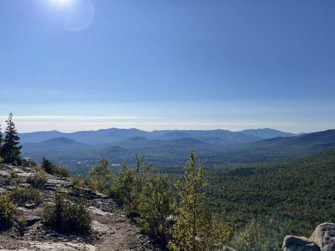
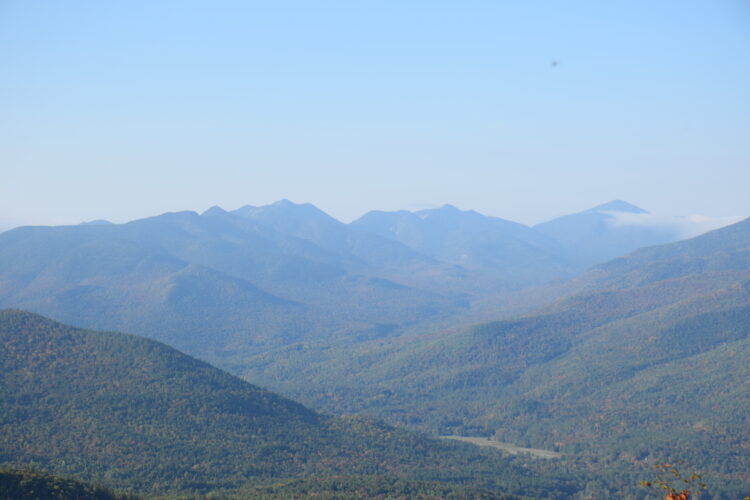
- News photos — Chris Gaige Algonquin Peak, the state’s second tallest mountain, is seen from atop Indian Falls on Sunday, June 8. Algonquin, along with Mount Marshall, Iroquois, Boundary and Wright peaks make up the MacIntyre Range.
- Lewis MacMillan leisurely consults the trail map at the Indian Falls scenic lookout on Sunday, June 8.

News photo — Chris Gaige Lewis MacMillan, left, and Chris Gaige smile atop Mount Marcy on Sunday, June 8 with Mount Skylight in the background to the right.
LAKE PLACID — After 10 months of exploring the Olympic Region, much of it spent on the trails, one notable peak remained off of my list that I had wanted to do since I took over the Visiting Lake Placid Column: Mount Marcy.
Its mark on the landscape looking south from Lake Placid is indelible. It’s one of the most popular hikes in the region. Towering at 5,344 feet, Marcy is the tallest mountain in the state. Its summit offers unimpeded, 360-degree views with almost every one of the 46 High Peaks visible.
I wanted to save the hike for a special occasion and last week was just that: I was on vacation and one of my friends from college, Lewis, was visiting for the week. Fortunately, Lewis came prepared with ample hiking experience — Mount Marcy isn’t exactly a beginner’s trek.
I kept an eagle eye on the weather in the days leading up to the hike, careful to avoid getting us stuck hundreds of feet above the treeline in the midst of a lightning storm or on the trails during an all-day deluge. As it would be, the forecast kept me on my toes.
The weather models seemed to change on the hour in the days leading up to the hike, unable to make up their mind between sun or storm. Finally, things seemed to fall in place, and it looked like we’d have a couple of days without precipitation or other severe weather, just some pesky wildfire smoke that would partially obscure those aforementioned views. I told Lewis to temper his expectations.

News photos — Chris Gaige Algonquin Peak, the state’s second tallest mountain, is seen from atop Indian Falls on Sunday, June 8. Algonquin, along with Mount Marshall, Iroquois, Boundary and Wright peaks make up the MacIntyre Range.
After picking Lewis up from the Westport train station Saturday, June 7, we drove directly to the Adirondak Loj, a destination in its own right, and headed into the woods. I had spent much of the previous day, and that morning, packing food, clothes and camping gear so we were set to go. Our path was the Van Hoevenberg trail, the most popular of several trails that lead to Marcy’s summit.
Visitors should note that there is a daytime and overnight parking fee at the Loj. The proceeds support the Adirondack Mountain Club, which owns the Loj, surrounding buildings around Heart Lake and the parking lots. A nonprofit organization, the club’s mission is to protect wild lands throughout the state while promoting responsible outdoor recreation. For more information, including parking rates, Heart Lake amenities and the organization’s mission and history, visit adk.org.
Although Mount Marcy could be completed without issue in a single day, provided one is prepared for the hike and in good physical condition, we decided to make it a multiday hike, camping out the first night at Marcy Dam.
There are plenty of lean-tos and designated campsites in and around the (former) dam, and while they could all become occupied on a busy day, we were able to find a spot without issue.
It’s about 2-miles from the Loj to the dam. There’s a well-marked junction to Wright, Algonquin and Iroquois mountains that heads off to the right approximately halfway between the Loj and the Dam. When starting from the Loj, stay left here to get to the dam.

Lewis MacMillan leisurely consults the trail map at the Indian Falls scenic lookout on Sunday, June 8.
It’s an easy 2 miles. The trail is wide, well-drained and has no steep inclines. There are a few fairly gentle hills, and the trail gains about 200 feet over the course of the 2 miles. Take note, though, beyond Marcy dam that trail becomes considerably less forgiving.
That was, however, a separate issue for another day. OK, the next day. We got to the dam just as the light was starting to dim, with still just enough to pitch the tent without needing headlamps. We then went down to the water to catch up with each other, enjoy some dinner and marvel in Marcy Dam’s solitude and tranquility.
As golden hour turned to dusk, I carefully packed all of our remaining food for the next day, the wrappers and anything with a food scent that could attract a certain unwelcome nighttime visitor into a bear-resistent canister. Not only are the canisters far more effective than putting the food in a bag, stringing it around a tree branch and hoping for the best (bears are remarkable climbers) — but in the Eastern High Peaks Wilderness Zone, they are the law.
Overnight hikers are required to store any food in them between April 1 and Nov. 30 each year, with the state Department of Environmental Conservation Forest Rangers on patrol to enforce it. The law is for good reason — the canisters, while they come with a cost, are far and away the most effective way to prevent bears from coming after food, greatly mitigating any potential dangerous encounters.
In keeping with good practice, we stored the bear canister at least 150 feet away from our and any other campsite, cooking area and at ground level. For more information from the DEC on the canister regulations, reasons for it and ways to properly use them, visit tinyurl.com/y3jwf8nf.
Much to our surprise, the blackflies weren’t especially gnarly. They were present, but unlike previous hikes in past Junes, my hands weren’t constantly in motion swatting around my face, usually in vain. With a big day ahead, we filed into the tent, and it was ‘lights out’ shortly thereafter.
Though I can’t say I had the best night of sleep in that tent, I awoke with gusto, ready to tackle the rest of the way to Marcy. We took down the tent and stashed it nearby in the woods. Since we would be passing by the area on our way back down, there was no need to take the extra weight for a nearly 5-mile joyride in our backpacks while ascending about 3,000 feet.
With a June sunrise, we hit the trail early. The climbing got a bit steeper than the trail to Marcy Dam, but was still pretty maneagle. The more significant change was the trail’s composition. The once wide, smooth and dry trail turned into a rock field that resembled a military training obstacle course.
On top of that, things were wet, really wet. With the exception of a few dry splotches here or there, where there wasn’t a boulder, the trail was either deep mud, standing water, or a trickling stream — not a stream that the trail crossed, but the path itself seemingly was a stream. While the previous week did feature a lot of rain, those who have spent time hiking in the High Peaks know that these conditions can describe pretty much any trail in the mountains any time of year, when there’s not a deep snowpack. I spoiled the “surprise” to Lewis ahead of time to manage expectations and prevent morale from plunging 5 minutes into our hike.
The trail crosses Phelps Brook about 0.3 miles after Marcy Dam and comes to a junction with the trail to Phelps Mountain about a mile after the dam. The junction is well marked. If one is traveling uphill, the Phelps Mountain trail goes to the left while the Van Hoevenberg trail to Marcy continues straight/slightly right.
Approximately 0.3 miles after the Phelps trail junction, the Van Hoevenberg trail re-crosses Phelps Brook, this time over a bridge. This is where the first sustained stretch of steeper climbing begins. While there is nothing especially technical, and no scrambles are required, the stretch could leave one winded. There are a couple of junctions with an adjacent backcountry ski trail — which looks somewhat overgrown in the summer and is easy to discern from the hiking trail.
After about a mile of steady climbing, the trail begins to level off. A junction with the unmarked path to Table Top Mountain diverges to the left as one is heading uphill. Shortly thereafter, the trail reaches Indian Falls, an excellent break spot en route. The scenic lookout — which offers ample open and flat rock without getting too close to the waterfall’s ledges — provides spectacular views of the MacIntyre Range and surrounding peaks to the west.
Drinking water directly from streams is discouraged, given the bacteria. But, for those with a reliable filtration system, the falls is the last reliable water source to refill from before the summit.
After a relaxing break, Lewis and I continued along. While the trail was still rocky and wet, the 0.8 miles or so after the lookout are generally flat, providing a respite before the incline resumes. There are two intersections, first with the Hopkins trail, then the Phelps trail (not to be confused with the separate Phelps Mountain trail from earlier).
These routes both originate from Keene Valley, and provide excellent alternate and less busy routes than the Van Hoevenberg trail to Mount Marcy — albeit with slightly longer mileage. Both junctions are well-marked, with signage to avoid any confusion. Between those two junctions, the first glimpses of Marcy’s summit emerged through the trees.
Thanks to extensive work by the trail crews over the years, an elaborate stretch of boards and planks helps hikers stay atop what would otherwise be a very mucky alpine bog just before the trail climbs above the trees. This is where the real fun starts. Once above the treeline, my eyes were stuck to the prize as I could look up the ridge line to the summit most of the way.
Astonishingly, there was one entrenched patch of snow near the summit — on June 8 — and there were ski tracks on it. On our way back down, we passed an intrepid crew of backcountry skiers, boots and gear in tow, on their way up to catch some of the last turns of the season.
While the climbing is steep above the treeline, it’s not especially technical, compared to many of the other High Peaks, and there are no places where we had to scramble. Mentally, having the summit in view the entire time served as a constant reward, pushing us onward when, had things been obscured by a treeline, we probably would have otherwise taken many more breaks.
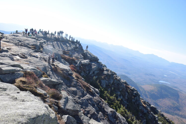
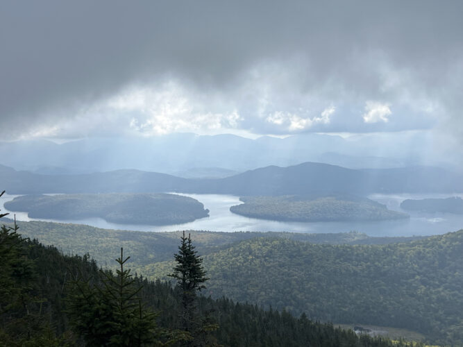
We made it to the summit in short order. As anticipated, the wildfire smoke cloaked much of the views, although numerous surrounding mountains, such as as Haystack, Skylight, Gray, Colden, Redfield, Cliff, Table Top, Phelps, Algonquin, Wright, Iroquois, Marshall, Basin, Haystack, Allen Gothics, Colvin, Blake, Nippletop, Dial, Dix, Hough, South Dix, Macomb and others were all still visible, in varying amounts of haziness. Lake Champlain, the village of Lake Placid and Whiteface were out of our view that day.
After taking in the views, and lunch, we made our way back down. The descent was more exhausting than anticipated. In many spots, the numerous boulders made it difficult to stretch the legs out and roll along at a good clip. With the long daylight, we weren’t in any particular rush. We stopped again at Indian Falls to take in the views, refill and refuel before traipsing our way down the steep section to Phelps Brook.
Back at the campsite, we grabbed our gear. It was all accounted for and intact. The extra weight on our shoulders felt as if someone had plunked some of those trail boulders into our packs. It was an easy two miles out, and the smoother trail actually let us pick up the pace toward the end. Before we knew it, we were back at the Loj, sitting in an air conditioned car.
Despite it being the tallest peak, Mount Marcy is generally considered one of the easier High Peaks, due to its relatively gradual ascent and absence of technical scrambles. Easier does not mean easy. The mileage is long. My GPS watch had us just over 15 miles, which included some of the side movements around the campsite the night before. The official mileage clocks in around 14.5, with an elevation ascent of 3,149 feet from Heart Lake to Marcy’s summit, a figure that is several hundred feet larger in reality, as hikers have to regain the various short downhill portions of the route.
For those in good hiking shape and are experienced in the Adirondacks, Mount Marcy’s allure is obvious. Its towering summit and spectacular views make for an excellent way to spend a long day, or incorporate an overnight camping foray en route, when visiting the Olympic Region.
Visiting Lake Placid
VISITING LAKE PLACID: Peak peace & crowds
VISITING LAKE PLACID: Fleeting fall colors from Flume Knob
VISITING LAKE PLACID: A tale of two trails
VISITING LAKE PLACID: Big scenes on the Crows
VISITING LAKE PLACID: McKenzie Mountain: False summits, true grit