SWIMMING THROUGH TREES: Kane Mt. to Camelhump(s) in the Shaker Mountain Wild Forest
Camelhump South (Provided photo — Spencer Morrissey)
Did you know that the Adirondack Fire Tower Challenge also has a winter category? Between Dec. 21 and March 21 you can work on your winter fire tower climbs and earn a really cool winter rocker.
My wife Corenne and I are closing in on the fire tower peaks for that as well, and I must say it’s a blast. Neither one of us can boast the accomplishment of having done them all in winter, so winter 2015 is where we started over.
I have managed to get a few over the years with no serious thought to doing them all, but why not. The mountains always do take on a new form in winter and end up offering a different kind of challenge you just don’t get in the summer.
Kane is just over the county line from Piseco, making this the perfect venture for anyone staying on the southern border of Hamilton County, or for anyone out for a nice adventure and a short hike. For me it was a 2-plus hour drive to visit Kane, and we were happy to do it.
I wanted to get a bit more of a day in the woods, so we decided to throw in a short bushwhack up Camelhump, also located in the Shaker Mountain Wild Forest and not that far away.
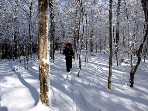
We arrived at the trailhead on Green Lake Road a shade after 10 a.m. with two cups of coffee. We were excited to get out of the car to stretch our legs (and also pee).
After we strapped on our snowshoes, we pushed on up the trail to the tower. Kane does not give the benefit of a quarter-mile or so flat warm up for sleepy legs. You start right off climbing. Not a big deal really, the slopes are not steep at all.
The trail was well-packed from countless snowshoers in the previous week. There was a light dusting of powdered sugar snow on the trees, and with a deep blue sky, the sun beams created a rather unforgettable setting.
As the trail swung around the base of the peak, we clearly noticed the summit was not the half-mile from the trailhead as the sign read, but more like the 0.8 miles that most maps depict.
Soon we were standing beneath the tower looking up the skirt, so to speak, curious if Abby would do it.
After we removed our snowshoes we started the climb. The stairs were a bit slippery but by no means a danger to the climber. Abby pushed on a flight at a time, between the two of us – looking back after each flight to see if we were either there or serious about continuing. Oh to be Dr. Doolittle at that moment would have been priceless.
Abby made it up about halfway before she turned around. Corenne and I finished the tower, one at a time. She was happy to be on the ground, you could truly see that.
We decided it would be a nice addition to the day to finish off the loop back to the car, so we did just that. It didn’t look as though the backside of the loop that leads down to Otter Lake gets used very often, however a faint track looked to be created by somebody.
The back loop section is about 1.5 miles in length, doubling the distance of the route up. We happily followed the trail as it headed almost due north toward Pine Mountain, leading us down a gentle ridgeline. About halfway down the trail it made a very hard right, and soon we found ourselves at the tip of Otter Lake looking at Camelhump across the way.
From the Kane Trail we hopped onto the Indian Lake Trail and started our hike along this attractive ski trail to two remote ponds. We didn’t need to go that far, though. We only remained on the trail for about 0.75 miles or so, until our GPS told us to start heading toward Camelhump.
While bushwhacking is not a sport for everyone, we really do enjoy seeing stuff off the beaten path and visiting peaks seldom seen. North and South Camelhump would be the ones for today. We scoped out the mountain from Kane and on our topo map, and located what looked to be a gentle slope of hardwoods that went between North and South Camelhump. We aimed for this as our route up being sure to avoid a postage stamp section of private land.
We broke trail easily through about three inches of powder on a deep, solid base and quickly found ourselves on the slope and looking up at the steep ledges of South Camelhump.
We remained on the slope as it continued to grow steeper and steeper. It didn’t take much effort to get around the peaks and quickly we found ourselves in a very deep valley between the two Camelhumps.
We opted to climb up to the summit of the smaller hump which was North Camelhump, which was less than 0.2 miles away. We looked for views in through the hemlocks atop the steeper slopes to the west, but we found nothing but obstructed overlooks back toward Kane. The wooded summit offered us nothing much either.
Back in the col with South Camelhump we needed to continue through the valley to find a decent route up, everything else was lined with massive rocky cliffs covered in ice. We soon found a steep slope that went through the hardwoods, but accessed us decently to the summit ridge.
The summit ridge, while open and covered in hardwoods, didn’t offer us any views either. We pushed into the hemlocks again atop the steep slopes of this mountain, but again found little excitement, but we enjoyed the seclusion nonetheless.
We descended a different route along the south shoulder of North Camelhump, open hardwoods and a steady slope gave us a quick descent back to our track in. While slippery, the slopes were an enjoyable glissade back to lower elevations.
Once back on our track in, we hit the trail and in no time flat we were back at the car sipping on a thermos of hot tea, that we never even touched while out in the woods.
Better late than never I guess, but I need to do better with cold weather liquid consumption that is not an IPA.
Columns

HISTORY IS COOL: 100 years ago
MARTHA SEZ: ‘It’s hard to believe that spring will ever arrive’
Every year on April 15, a day of dread made notorious by the U.S. Internal Revenue Service, I celebrate the ...

ON THE SCENE: More dedicated volunteer firefighters are needed

The solar eclipse watch party of one, sort of …

LIONS CLUB LOG: Town/village historian joins Lions Club
